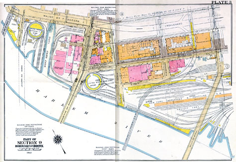
Bronx Map
as it was in ’42
Click on image for really, really big view. Its real big.
Enjoy!
-Tim
About the Author:
I'm your host, Tim Warris, a product developer in Port Dover, Ontario. Since March of 2007 I have been documenting the construction of the former CNJ Bronx Terminal in HO scale. For my day job, I design track building tools for Fast Tracks, a small company I own and operate. Fast Tracks makes it fast and easy to hand lay your own trackwork. Stop by our website to learn more!
Posted by: Tim | 03-22-2007 | 11:03 AM
Posted in: Latest Posts | Prototype Information (the real stuff)


Interesting map Tim. In following the progress of this new project, I was under the impression one or more of the paired tracks would lead to a float yard. I was surprised to see the tracks parallel to the river! From the map it appears they are all used for transfer to truck service. How are the freight cars brought in? What is the standard operating procedure here?
Very useful map Tim, thanks for sharing it. You don’t know if there’s a similar one of the Lehigh Valley and Erie terminals a little further north along the Harlem River by any chance??
Your Bronx build is simply awesome – I hope one day to do the similar Harlem Terminal yard, once I have the space available to me.
Your pointwork is superb – I’ve hand-built built UK finescale trackwork myself for my UK layouts, so I know how much thought and effort has gone into them.
Keep up the good work!
Regards,
Alan,
London, UK
Hello!
I like your project very much, and i’m very impressed of it. I couldn’t keep my fingers away from the map that you have posted, so I made this picture:
http://anto04.110mb.com/bilder/bronx_map_copy.jpg
Quit nice to see how the roads and buildings change through the time.
/ Anton
Alingsås, Sweden
Tim,
Have you seen this photo taken from the 129th Elevated Station on the Manhattan side of the Harlem River?
http://www.nycsubway.org/perl/show?41819
It is from the http://www.nycsubway.org web site.
Jay
Do you have a map of the area just to the east of the Terminal? Or does anyone?
Hi,
I purchased the map from the site below…
http://www.historicmapworks.com/
They may have others from the same area, just browse around their site, there is lots of good stuff there…
Tim